With temps near 90 degrees
the last two days in Jackson Hole it is hard
to even think about snow and the coming Winter Season. But it happens every
year in late August, the questions begin as to, “What kind of winter are we
going to have?”
With the start of the Fall
Season still three weeks away and Winter officially another three months beyond
that, it seems silly to even start worrying about it while still in my shorts
and flip-flops.
The reason the question gets
raised this early in ski towns is because people are trying to make that
decision of whether or not to buy a season ski pass, at the discounted rate,
before the prices go up in September.
(Reminder: Prices increase Sept 1st for the Jackson Hole Mountain Resort. After Sept. 16th for Grand Targhee).
(Reminder: Prices increase Sept 1st for the Jackson Hole Mountain Resort. After Sept. 16th for Grand Targhee).
My standard answer to this
annual question is, “It will be a great winter!”
After spending most of the
last 30 of them here in Jackson Hole, I can
tell you that a lean winter here still beats a good winter almost everywhere
else! Sure, we’ve had our BIG winters that everyone would like to see repeated
every winter (2010-11, for instance), but even when we have had lower snowfall
winters, we’ve still had some tremendously great skiing.
So, let’s look at what the
long range forecasts are saying for the upcoming Winter Season 2012-13.
Long Range Outlooks
A sneak peek at the Old Farmer’s Almanac, which comes out
this week, tells a tale of warmer than normal temperatures for the Northwestern U.S. with below normal snowfall. They could
be wrong, as they were way off on last winter’s prediction, after all.
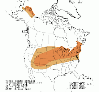
The Climate Prediction
Center (a division of
NOAA and the National Weather Service) does show the start of the season,
October-November- December with warmer than normal temps and “equal chances”
for above or below normal snowfall.
(See maps below and keep up
with all the latest short & long range outlooks on the
NWS Discussions Page of mountainweather.com)
NWS Discussions Page of mountainweather.com)
3-Month
Outlook Maps for October-November-December 2012
|
|
|
|
|
Temperatures
|
Precipitation
|
El Nino Year
The fluctuation in the Equatorial
Pacific that we commonly refer to as “El Nino & La Nina” is technically
known as the “El Nino Southern Oscillation (ENSO)”. This is what the Climate Prediction Center
focuses a lot of their time on when making these long range forecasts.
Last Winter (2011-12) we
were also in a La Nina year, weaker than 2010-11’s, and the storm track went
way north to Alaska
most of the Winter & Spring of 2011-12. That is one of the things that can
happen in some La Nina years. Or, it can get locked in over the Northwestern
U.S. and Northern Rockies, like it did two
winters ago, 2010-11, when winter didn’t end until June!
Most of the Summer of 2012
we have seen a “Neutral” condition with the ENSO, and now we are trending
towards a weak to moderate El Nino
condition that is expected to persist for the Fall & Winter of 2012-13.
Usually, during El Nino
winters, the storm track coming out of the Pacific favors a more southern
route, and the Southwestern U.S. gets more
precipitation. The opposite of a “normal” La Nina, where the Northwestern
U.S. is favored and the Southwest is dry.
Don’t let that scare you,
because statistically El Nino for us is a 50/50 proposition. Half of El Nino
Winters in Jackson Hole produce below normal
snowfall and half produce above normal snowfall.
The last time we had “weak” El
Nino conditions was during the Winter of 2006-07, with below average snowfall. The last time we had moderate El Nino conditions was the Winter of
2009-10, and we saw above normal snowfall.
A 50/50 bet seems like decent
odds to go ahead and buy that Season
Pass!
Chart below of ENSO Index
(El Nino years in blue and La Nina Years in red.)
(El Nino years in blue and La Nina Years in red.)
Text submitted by meteorologist Jim Woodmencey
Graphics from NOAA


No comments :
Post a Comment